
OVERVIEW
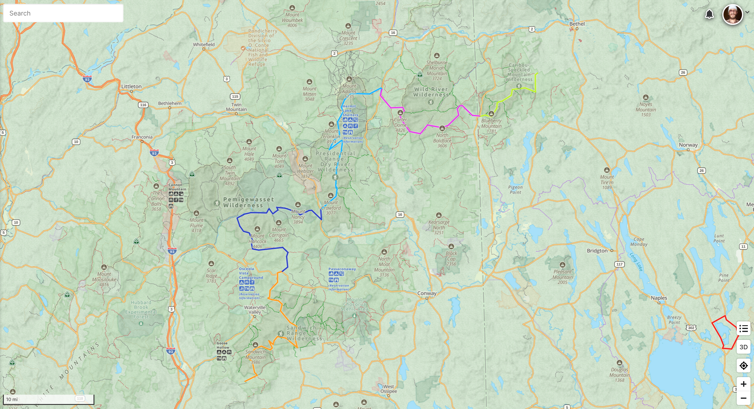
The White Mountains Wilderness Route is a 115 mile network of trails that connects all 6 federally designated wilderness areas in the White Mountains National Forest; the Caribou-Speckled Wilderness, Wild River Wilderness, Great Gulf Wilderness, Presidential Range-Dry River Wilderness, Pemigawassett Wilderness, and Sandwich Range Wilderness.
Starting at the Miles Notch Trailhead in Stoneham, Maine and ending at the Guinea Pond Trailhead in Sandwich, New Hampshire, the White Mountains Wilderness Route summits, passes, or comes in close proximity to the following natural landmarks:
Red Rock Mountain, Butters Mountain, Durgin Mountain, Speckled Mountain, Bickford Slides, Basin Brook Reservoir, Hermit Falls, Mount Meader, Eagle Crag, Perkins Notch, Carter Dome, Mount Hight, Spaulding Lake, Great Gulf Headwall, Oakes Gulf Headwall, Mount Isolation, Mount Davis, Stairs Mountain, Crawford Mountain, Nancy Cascade, Nancy Pond, Still Water Junction, Hancock Notch, North, Middle, South Tripyramid, West, East Sleeper, Sandwich Dome, Black Mountain Pond, and Guinea Pond.
This particular route was first completed by Philip Carcia and Andrew Soares on July 9th, 2023 in a total elapsed time of 84 hours.
VISION
After hiking the White Mountains Guide cover to cover three times in the last three years, the potential for a route of this magnitude, tying-in each of the Wilderness areas was obvious and immediately struck me as something I wanted to help establish.
Along with guidance, expertise, and insights from fellow White Mountains hiker Declan Kiley, this was the route that came to fruition.
In many respects, the White Mountains Wilderness Route is the Anti-Direttissima; the true underbelly of the White Mountains National Forest. But what does that mean? The intention for the WMWR is not to lead a hiker across iconic 4,000-footers or easy to identify landmarks, although admittedly there are several of both on this route.
The primary goals of the WMWR are to:
Connect all 6 federally designated wilderness areas in the White Mountain National Forest, balancing both practicality and aesthetic.
Avoid well traveled trails commonly used to access the New Hampshire 4,000-footers.
Give the accomplished White Mountains athlete an opportunity to explore and test themselves in the most remote corners of the National Forest.
ROUTE
Segment 1 • Caribou Speckled Wilderness • 11.1 miles, 3,158’ vertical gain
The eastern terminus of the WMWR is located at the Miles Notch Trailhead in Stoneham, Maine. Moving westbound, the route is connected by the following sequence of trails: Miles Notch Tr > Red Rock Tr > Blueberry Ridge Tr > Bickford Brook Tr > Brickett Place, Route 113.
Segment 2 • Wild River Wilderness • 19.6 miles, 6,204’ vertical gain
The WMWR leaves Brickett Place and follows Route 113 to Basin Pond Rd. and eventually the Basin Pond Trailhead. Moving westbound, the route is connected by the following sequence of trails: Basin Tr > Basin Rim Tr > Meader Ridge Tr > Eagle Link Tr > Wild River Tr > Rainbow Tr > Carter Moriah Tr > Carter Dome Tr > 19 Mile Brook Tr > 19 Mile Trailhead, Route 16.
Segment 3 • Great Gulf & Dry River Wilderness • 25.4 miles, 7,994’ vertical gain
The WMWR leaves the 19 Mile Trailhead and follows Route 16 to the Great Gulf Trailhead. Moving westbound, the route is connected by the following sequence of trails: Great Gulf Tr > Gulfside Tr > Crawford Path > Dry River Tr > Isolation Tr > Davis Path > Davis Path Trailhead, Route 302.
Segment 4 • Pemigawassett Wilderness • 25.8 miles, 4,628’ vertical gain
The WMWR leaves the Davis Path Trailhead and follows Route 302 to the Nancy Pond Trailhead. Moving westbound, the route is connected by the following sequence of trails: Nancy Pond Trail > Carrigain Notch Tr > Wilderness Tr > Cedar Brook Tr > Hancock Notch Tr > Sawyer River Tr > Sawyer River Trailhead, Route 112.
Segment 5 • Sandwich Range Wilderness • 27.2 miles, 7,854’ vertical gain
The WMWR leaves the Sawyer River Trailhead and follows Route 112 to the Livermore North Trailhead. Continuing westbound, the route is connected by the following sequence of trails: Livermore Tr > Mount Tripyramid Tr > Kate Sleeper Tr > McCrillis Tr > Flat Mountain Pond Tr > Bennett Street Tr > Algonquin Tr > Black Mountain Pond Tr > Guinea Pond Tr > Guinea Pond Trailhead, Sandwich Notch Road.